 | ||||
Haslemere Charter FairMonday 6th May 2024 | ||||
| Home | Stallholders | What's On | About | Contact |
|
The Celtic or Romano-British population of around the 1st and 2nd centuries A.D. left quantities of pottery mostly associated with burials, in the Beech Road area as well as isolated examples at High lane, Farnham Lane and elsewhere, but we do not know where these folk lived. The Saxons must have been in the area for the very name of Haslemere, in its original form, is derived from the name of a Saxon tribe. The history and antiquarian Aubrey, writing in 1718, refers to a tradition that the town once stood in the region of Haste Hill and was a place of some importance, not supported by any substantial archaeological evidence so far. It would seem that there were a number of scattered small areas of
population in former times: for example at Piperham (another Saxon
place name) which is in the area around St Bartholomew's church and
is recorded in ancient manuscripts. Other ancient settlements are
in the vicinity of Bunch Lane, Coombswell and elsewhere. It had been included in the borough of Godalming and was originally given to the then Bishop of Salisbury by Henry II in 1185. There is much evidence to suggest that Haslemere was a planted town with a characteristic T -shaped form similar to other planted market towns in Surrey. This was a common custom in the 12th and 13th centuries.
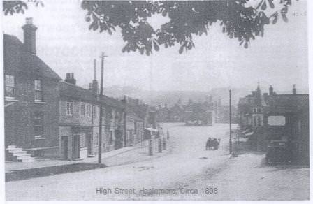
The earliest known map of the Borough of Haslemere is in the Museum. It is a hand-coloured plan by William Morley of "1722 or thereabouts" and it shows the T-shaped design with its Market House surrounded by various auxiliary buildings, the High Street, Cow Street (now Petworth Road), Shepherds Hill, the town wells etc. Each building is carefully depicted and this gives us a good idea of the appearance of Haslemere in those days. An important feature of this map is that the High Street comes to an abrupt end to the north and there is no direct road through to Godalming and beyond. This reminds us of the relative isolation of the town and its community in early times. A map of 1775 shows the newly established turnpike road on its way to Godalming and, at the same time; we can see that the appearance of many of the houses has been substantially altered in the intervening years. This suggests a period of some prosperity between the dates of these two maps. Our present Town hall was built in 1814 and the Museum has a watercolour drawing of this building, in its original state, dated 1822. The Reform Bill of 1832 led to Haslemere losing its borough status and right to elect members of Parliament. Thus our story shows how from being a scattering of minor settlements the centre of Haslemere was laid out and established as a market town and parliamentary borough. It had a small population and was relatively remote; and isolated so that it retained its identity for a long time. With the arrival of the turnpike road and then the railway, in 1859, improved communications diminished this isolation. This process has, of course, accelerated in recent years. In June 2022, our High Street will again be closed to the north as it was before 1775 and the people of Haslemere can re-live the customs and merrymaking of their forebears at the fair. Throughout the centuries Haslemere has managed to retain much of its character and, in spite of inevitable developments in recent times, it has kept some of its unique quality. We must be grateful for the careful steward- ship of the Haslemere Preservation Society, the National Trust Committees and our local authorities for their splendid efforts in this connection. |
| |||
|
©Haslemere Events 2024. Haslemere Events events@haslemere.com | ||||